Among all types of infographics, maps are my favourite kind. It’s really fascinating how much information a well-designed map is able to communicate. And this makes subway maps both a challenge and a nightmare to designers.
Long before cars became our primary means of transport, the use of interurban transit provided commuters a way of traveling big distances inside a city. In 1933 the first subway map was created by Harry Beck: London Underground, a classic which then got imitated by many other means of transport. His design was inspired by electrical circuit diagrams, leaving aside the geographic references in order to make it clearer. Quite a lot has happened since then.
Much can be learnt from subway designs, and this is why I think some examples around the world can be very inspiring. I’ve tried (unsuccessfully) to find all the designers behind these maps so if anyone finds out any of the ones missing please help me to complete this list.
I’ve tried to be as accurate as possible concerning dates and facts*, but if anyone sees a mistake, please leave a comment and I’ll revise.
1. London (UK)

Year opened: 1863
System Length: 402 km (250 mi)
Map Designer: Harry Beck (1931), H. Hutchison (1960), Paul Garbutt (1964)
2. New York (US)

Year opened: 1868 (Elevated),1904 (Subway)
System Length: 373 km (232 mi)
Map Designer: Michael Hertz Associates (1979)
3. Budapest (Hungary)

Year opened: 1896
System Length: 30.8 km (19.1 mi)
Map Designer: ?
4. Boston (US)

Year opened: 1897
System Length: 61 km (38 mi)
Map Designer: Mikheil Kvrivishvili (2013)
5. Chicago (US)
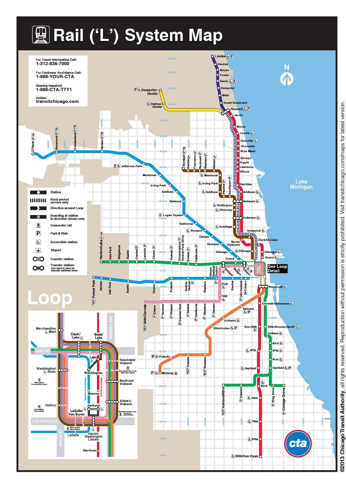
Year opened: 1897
System Length: 165.4 km (102.8 mi)
Map Designer: ?
6. Paris (France)

Year opened: 1900
System Length: 213 km (132 mi)
Map Designer: Jean-Baptiste Berlier (1900)
7. Berlin (Germany)

Year opened: 1902
System Length: 151.7 km (94.3 mi)
Map Designer: ?
8. Athens (Greece)

Year opened: 1904
System Length: 79.6 km (49.5 mi)
Map Designer: ?
9. Buenos Aires (Argentina)

Year opened: 1913
System Length: 47.1 km (29.3 mi)
Map Designer: Diseño Shakespear Argentina (2010)
10. Madrid (Spain)

Year opened: 1919
System Length: 293 km (182 mi)
Map Designer: Juan de la Mata (1920), Estudio RaRo S.L. (2007)
11. Tokyo (Japan)

Year opened: 1925
System Length: 34.5 km (21.4 mi)
Map Designer: ?
12. Moscow (Russia)
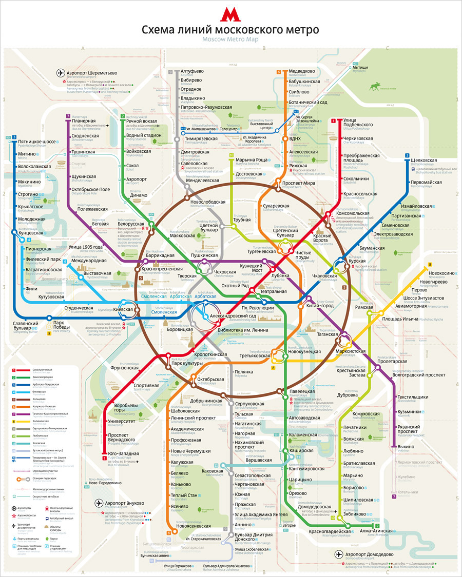
Year opened: 1935
System Length: 317.5 km (197.3 mi)
Map Designer: Art. Lebedev Studio (2010)
13. Lisbon (Portugal)

Year opened: 1959
System Length: 45.5 km (28.3 mi)
Map Designer: ?
14. Kiev (Ukraine)

Year opened: 1960
System Length: 67.5 km (41.9 mi)
Map Designer: ?
15. Montréal (Canada)

Year opened: 1966
System Length: 69.2 km (43.0 mi)
Map Designer: ?, Thomas J. (proposal 2009)
16. Oslo (Norway)

Year opened: 1966
System Length: 84.2 km (52.3 mi)
Map Designer: 2012 ?
17. Mexico City (Mexico)

Year opened: 1969
System Length: 226.5 km (140.7 mi)
Map Designer: Lance Wyman
18. Beijing (China)

Year opened: 1971
System Length: 456 km (283 mi)
Map Designer: Zhang Lide (1984)
19. Pyongyang (North Korea)

Year opened: 1973
System Length: 22 km (14 mi)
Map Designer: Sakazaki Motohiko (2007)
20. Seoul (South Korea)

Year opened: 1981
System Length: 320.5 km (199.1 mi)
Map Designer: ?
21. Caracas (Venezuela)
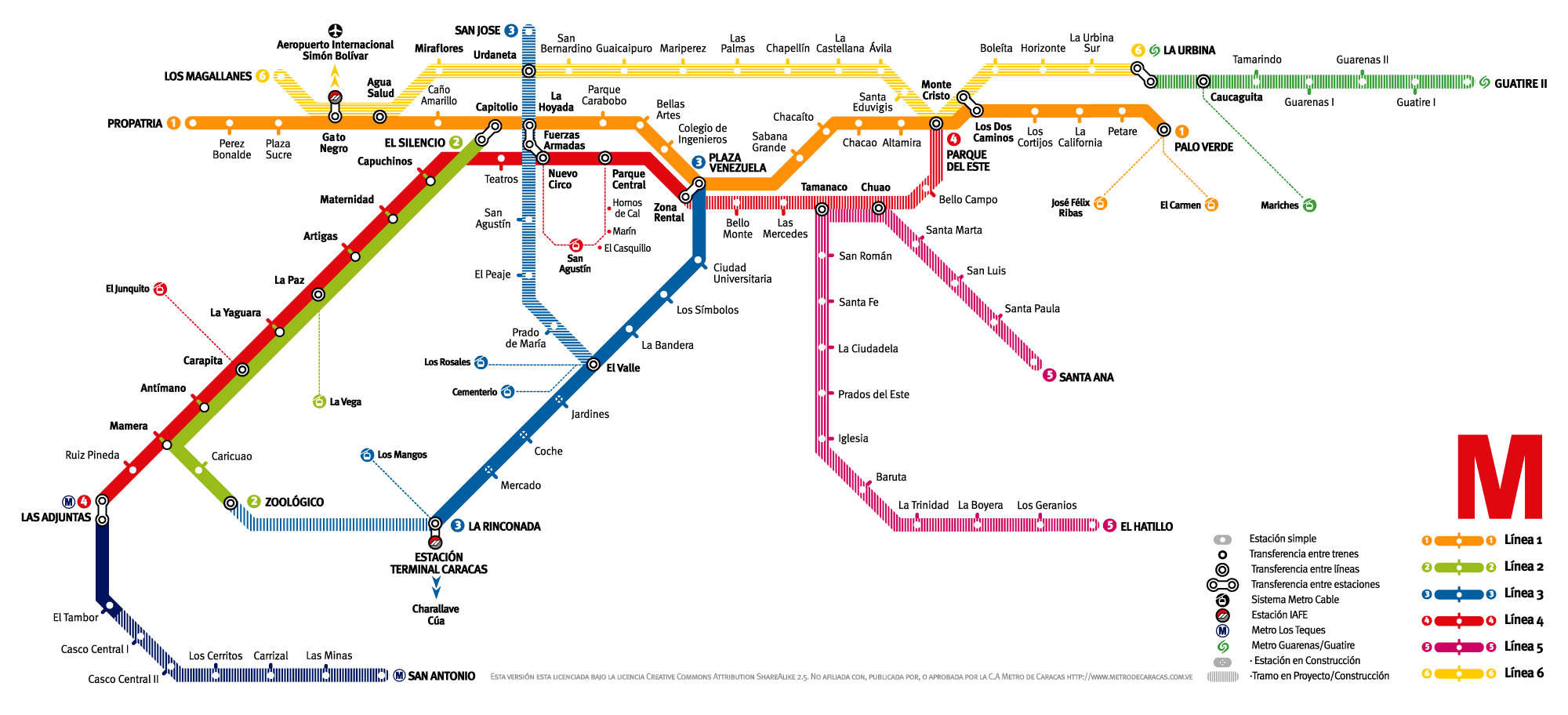
Year opened: 1983
System Length: 54.2 km (33.7 mi)
Map Designer: ?
22. Singapore (Singapore)

Year opened: 1987
System Length: 146.5 km (91.0 mi)
Map Designer: Land Transport’s Master Plan 2013
23. Istanbul (Turkey)

Year opened: 2000
System Length: 141 km (88 mi)
Map Designer: ?
24. Brasília (Brazil)

Year opened: 2001
System Length: 42.4 km (26.3 mi)
Map Designer: ?
25. Almaty (Kazakhstan)

Year opened: 2011
System Length: 8.5 km (5.3 mi)
Map Designer: Gleb K. Samoilov (2013)
*All technical information is based on this source.
Further reading: I really enjoyed the diagrams in this article about the world’s largest subway maps.

Very interesting post Virginia, well researched.
LikeLike
Thanks Mark. Any favourites? What do you think about London’s map?
LikeLike
Some of those maps make me feel very confused. Oslo and Portugal are probably the easiest for me to understand.
LikeLike
Some are indeed confusing. However, the total length of the system need to be taken into account and probably the number of stops would have been useful too. Density can prove to be quite a challenge. I’ve been in Lisbon and it was quite simple to understand by the way. Have you been in any of these?
LikeLike
No, sadly.
LikeLike
What about Berlin? I remember you telling me about a trip to Germany.
LikeLike
Very nice! I’ve used London, Paris, New York, Tokyo, Madrid, Chicago, and Boston. Tokyo is much easier than most people think.
LikeLike
You’ve used quite a lot of them! Is Tokyo really easier than it looks? If you had to choose one of those subways for its clarity which would it be? I’ve got to say that Madrid is really easy to use.
LikeLike
Madrid is very easy! Tokyo’s challenge is that it is a collection of several different systems, owned by different companies. You often have to buy another ticket to make connections if you don’t figure out the correct transfer combination 🙂
LikeLike
Oh, that was unexpected! So it isn’t owned by the government? Is it more like a private service? That’s very curious in fact. The smarter you are the less you’ll pay, right?
LikeLike
I think they were originally built by the companies that owned the big department stores, with stations in the store! So convenient 🙂
LikeLike
Love this post! I used Chicago,NYC and Paris transportation . Maybe you you would like to add Paris map, it’s one of the best transportations in the world.In terms of confusion I find Japan’s map extremely confusing!! Thank you again!!:)
LikeLike
And between all those 3 which one seemed better in terms of clarity? I remember New York’s subway being quite confusing. It took us a while to figure out several trains stopped on the same platform. I’ve never been to Japan but it looks like a nightmare to me too haha. Oh and Paris’ is number 6 😉
Good to see you here 🙂
LikeLike
Well I like Chicago’s best,but I found Paris plan not bad at all!We quickly understood it.
I agree with you , NewYork’s was a little confusing.
Great post !
LikeLike
What a fabulous collection of maps! One of the interesting things about the London Underground is that there are a few stations that look quite far apart on the map but are actually almost on top of each other… the map is beautiful in its design and symmetry but it is often very deceiving. I always enjoy your blog!
Best,
James
LikeLike
Hello James, good to see you here 🙂 I though of the same when I visited it. Sometimes we went walking and when I checked the distance on the map it looked further away. But besides that, it was clear and easy to understand how it works. Also, I liked the low height of the ceilings in the trains, it made it kind of cozy 🙂
LikeLike
Of course London is always my favorite! But I am happy to say Los Angeles is back on track (so to speak). At its height LA had about 1200 miles of rail taking people to every corner of Greater Los Angeles. By the 1960s that was zero as the freeways and cars had taken over. But in 1990 the Blue Line opened and today we have six lines and 90 miles of rail… a long way to go but it is happening despite the NIMBYs (Not In My Neighborhood!). Riding on the underground Red Line I always feel like I am back in London. It is exciting. All the train lines are experiencing at least double the ridership that was expected… and we can only go up from here! Thanks for posting these maps.
LikeLike
I didn’t about Los Angeles subway. When I visited the city we went by car and I can only remember the traffic jams! So having a good urban infrastructure makes a lot of sense. The NIMBYs made me laugh. I didn’t know about its big growth either, sounds like the city is doing better and better. Do you think it will continue expanding?
LikeLike
Milan. 92 km year1964
LikeLike
Thanks for sharing Leo 🙂 In your opinion is the subway system easy to use?
LikeLike
The easiest subway to understand must be Glasgow, one of the world’s oldest, affectionately known as the Clockwork Orange.
LikeLike
Should have added Glasgow too! I didn’t know it was know as the Clockwork Orange so thanks for sharing. Have you been in any of the other subways?
LikeLike
Yes, London, Berlin, New York and Budapest. How about you, Virginia?
LikeLike
I’ve been in London, Berlin and New York too. Also Mexico, Paris, Buenos Aires, Madrid, Chicago, Boston, Athens and Lisbon. And I am really curious to visit Tokyo and Mecca 😀
LikeLike
It’s a toss-up between Mexico City and Saudi Arabia . . . hmmm . . . not that I would ever ride any of them unless under duress.
LikeLike
hahah really? Well, to me the Mecca subway map is quite beautiful although I don’t think is very useful. Mexico it looks kind of a mess but it’s not that bad, actually when I visited the city I thought it would be harder than it turned out to be. What about the others? Did you get a chance to visit some of these?
LikeLike
The only two subways I have used are Washington DC and Chicago, although both are a mix of elevated train tracks and subway tunnels.
I don’t particularly like public transportation as there are usually way too many other people around.
As for choosing those two, it was just my estimate of two maps that would be somewhat useless unless one is already familiar with the lines.
I can also say with a fair degree of confidence I will not be riding either of those two . . . ever.
There are a few I might get a chance to use, but no immediate plans for it. Likely, even if I am at those places, I would avoid the subway . . . except Tokyo . . . maybe.
LikeLike
I’ve ridden on several of those (London, New york, Boston, Chicago, Buenos Aires, Madrid, Montreal, Beijing, Oslo, Berlin). I should note that your map for Istanbul is out-of-date. 🙂
They’re in the process of adding lines and extensions to current lines. All of Istanbul seems like one giant construction site.
LikeLike
Hey Richard, thanks for the correction! Just updated the map of Istanbul! I have to ask, which subway map was clearer in your opinion?
LikeLike
You’re welcome! The clearest maps were London, Paris, and B.A. Seoul and Tokyo make me think you need a magnifying glass to read them. Of course, that could be because there are so many stops and only so much space on the maps.
LikeLike
Virginia, this is wonderful! I’ve ridden on the majority of these systems, but not Almaty – and I find myself strangely drawn to this beautiful, stylish map. 🙂 ~ Terri
LikeLike
I found Almaty really curious too! I’ve never been either. Which were the best and the worse subway maps/systems in your opinion?
LikeLike
Virginia, I was amazed at how similar the visual lines of Istanbul and Mecca were – both very Islamic with a calm, graceful esthetic. I found Montreal’s black background less appealing. ~Terri
LikeLike
Hi Virginia,
I found your blog via an update from Kersten Harries. Your posts are very refreshing! I have added links to your city guides and maps to my blogs about Travel Resources for Architects on my Architects House Exchange website,
http://www.architectshouseexchange.com/blogs/1/23/travel-resources-for-architects and
http://www.architectshouseexchange.com/blogs/1/28/travel-resources-for-architects.
I update these blogs when I come across new resources.
I also just set up a LinkedIn group for all things travel related just for architects, The Architects Travel Network, http://www.linkedin.com/groups/Architects-Travel-Network-7418918/about. You are welcome to join and start and contribute to discussions if you are interested!
Eva
LikeLike
Eva,
Thanks for including my links to your site, which by the way looks amazing. Love the idea. Many useful information regarding events, magazines and other resources.
Just joined the group and I’m currently signing up on your web.
Virginia
LikeLike
Hi Virginia,
Delighted you joined the LinkedIn Group and that you would like to join Architects House Exchange!
There are lots of people doing great work in the area of travel for architects: it’s good to make connections, I believe that there is strength in numbers. I just read your post about the Julius App, look forward to more updates!
Eva
LikeLike
Hey Virginia. We’re in Morelia, Mexico and have an architectural question. And since you were in San Miguel, we thought you would be the perfect person to ask. We’d like to send a couple of photos for and ID, but we couldn’t find an email contact. If you’re interested, send an email to gallivance@gmail.com. Thanks. ~ James
LikeLike
Looking forward to see the post about Morelia 🙂
LikeLike
How amazingly interesting. Great Post!
LikeLike
Thanks for the kind words 🙂
LikeLike
I have only used London, Paris, Madrid, and Montreal from your list. I am also fascinated by these maps and their relationship to “real” maps.
LikeLike
This kind of maps are fascinating to me too! How is Montreal’s subway, is it easy to use? Have never been in that one?
LikeLike
I can’t say much about Montreal’s subway as I was with a local person who took the lead.
LikeLike
That’s the best way to visit the city! Did you like it? Lots of architecture?
LikeLike
I have been to Montreal three times. It is a lovely city at all times of the year. The Old Town is charming. During my winter visit the airport was closed for a few days due to very heavy snow. The temperature at night was bitterly cold. Because of the low temperatures there are a number of large shopping centres totally underground. Many large office blocks have their own underground connections to the metro system.
LikeLike
Seeing other countries layouts for subways really makes me appreciate how simple it is in Washington DC
LikeLike
I won’t complain about Chicago’s subway either 😀
LikeLike
Nice Job. However, there seems to be one major error. The NYC subway map you show is not the Map designed by Mike Hertz. you can find a version of the Hertz map at this website, http://web.mta.info/nyct/maps/mapsys.pdf.
Please email me and privately, and I will give you send you Mike Hertz’ email for clarification, or more info.
LikeLike
Pingback: Design: Infographics (II) | Virginia Duran
Pingback: Design: Infographics | Virginia Duran
The map of Montreal’s metro is completely wrong – there are only four lines, actually. The one posted on this page is a fantasy map.
LikeLike
Hi Phil! Thanks for the input, you are right. I updated the image to the current metro map. Apologies for the inconvenience 😓
LikeLike
That’s a nice collection of maps, indeed! You may want to add this, too: http://www.rudi-meyer.com/travaux/cartographie/001.htm. Cheers!
LikeLiked by 1 person
Thanks for the suggestion.
LikeLike
That’s a very nice overview of maps, indeed. Maybe, you want to add this, too: http://www.rudi-meyer.com/travaux/cartographie/001.htm. Cheers!
LikeLike